| |||||||
Europe
North AmericaSouth AmericaAsiaAustralia and OceaniaAfrica |
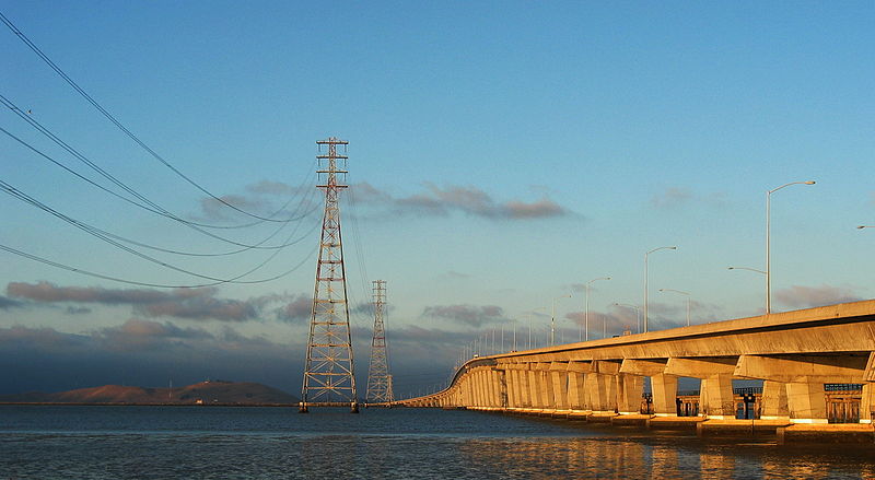
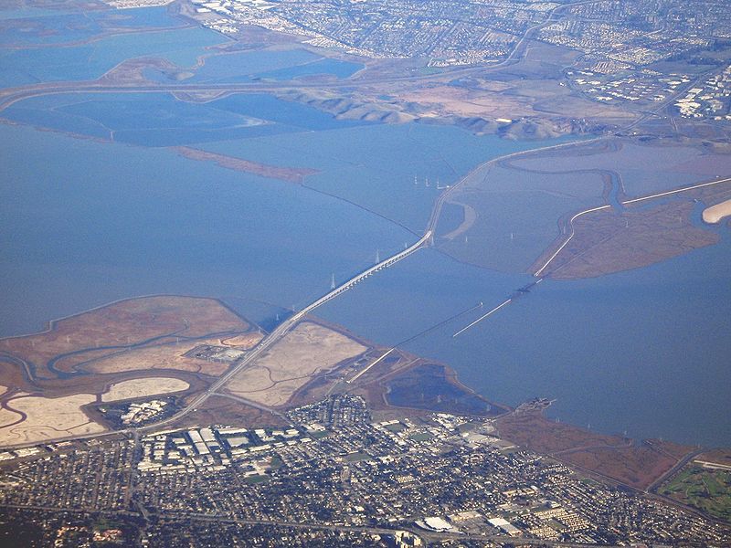
Смотрите также: Dumbarton Bridge The Dumbarton Bridge is the southernmost of the highway bridges that span the San Francisco Bay in California. Carrying over 81,000 vehicles daily, it is also the shortest bridge across San Francisco Bay at 1.63 miles (8,600 feet / 2,622 m). Its eastern terminus is in Fremont, near Newark in the San Francisco Bay National Wildlife Refuge, and its western terminus is in Menlo Park. The bridge has three lanes in each direction, and features a separated bike/pedestrian lane on its south-facing side. Like the San Mateo Bridge to the north, power lines parallel the bridge across the bay. Tolls are collected in the westbound direction at the toll plaza, which is located on the eastern side of the bay; the toll as of 2008 is $4. There are six toll lanes at the plaza; the leftmost two are dedicated FasTrak lanes. An additional carpool lane to the left of these can be used for free during weekday morning and afternoon commute hours by vehicles carrying two or more persons, motorcycles, or hybrid vehicles with a permit decal.
Dumbarton Bridge Carries 6 lanes of SR 84, bike/pedestrian Crosses San Francisco Bay Locale Menlo Park, California and Fremont, California Longest span 103.63 meters (340 ft) Total length 2,621.28 meters (8,600 ft) Clearance below 25.91 meters (85 ft) (main span) Opening date October 1982
History and engineering features The bridge never was officially named, but the common use name comes from Dumbarton Point, which dates to 1876 when it was named for Dumbarton in Scotland. Built originally to provide a shortcut for traffic originating in San Mateo and Santa Clara Counties, the bridge served industrial and residential areas on both sides. The earlier bridge, opened on January 17, 1927, was the first vehicular bridge to cross San Francisco Bay. Portions of this old drawbridge remain as fishing piers. The original bridge was built with private capital and then purchased by the State for $2.5 million in 1951. Its age and the limitations of a two-lane undivided roadway and lift-span made it necessary for a replacement bridge to be constructed to the north. This current bridge, a six-lane, high-level structure, was opened to traffic in October 1982. The cost of the complete replacement project was $200 million. The current bridge has a shoulder in each direction for emergency use and a two-way bicycle and separate pedestrian path on the south-facing side. A 340 ft (104 m) center span provides 85 ft (26 m) of vertical clearance for shipping. The approach spans on both sides of the Bay are of pre-stressed lightweight concrete girders supporting a lightweight concrete deck. The center spans are twin steel trapezoidal girders which also support a lightweight concrete deck. Connections to the western circulation system The bridge is part of State Route 84, and is directly connected to Interstate 880 by a freeway segment north of the Fremont end. However, it is not directly connected to US 101 at its southwestern end in Menlo Park. Motorists must traverse one of three at-grade routes to connect from the Bayshore Freeway to the bridge. These are (north to south) the Bayfront Expressway, linking to 101 at Marsh Road, Atherton (the official routing of SR 84), or via another mile of frontage road, to Seaport Boulevard/Woodside Road, Redwood City; Willow Road, approximately one-mile expressway through east Menlo Park to 101; and University Avenue, the main commercial street of East Palo Alto. Although this has led to severe traffic problems on the bridge itself and in Menlo Park and East Palo Alto, Caltrans has been unable to upgrade the relevant portion of Highway 84 to Interstate standards, due to opposition from the cities of Menlo Park, Atherton and Palo Alto. The freeway opponents fear that upgrading Highway 84 will encourage more people to live in Alameda County (where housing is more affordable) and commute to jobs in the mid-Peninsula area, thus increasing traffic in their neighborhoods to the south of the bridge. Bus service across the bridge is provided by the Dumbarton Express, run by a consortium of local transit agencies (SamTrans, AC Transit, VTA and others) which connects to BART at Union City and Caltrain at Palo Alto and California Avenue.
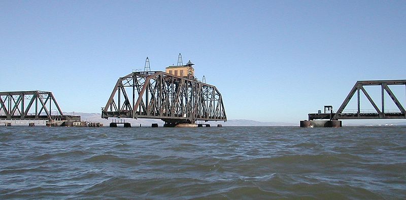
Dumbarton Rail Bridge Just to the south of the car bridge lies the Dumbarton Rail Bridge. Built in 1910, the rail bridge has been unused since 1982 and its western approach collapsed in a fire in 1998. When in use, boaters would signal the bridge operator who would start a diesel engine and rotate the bridge to the open position on a large gear. The bridge is now left in the open position as shown. There are plans for a new rail bridge and rehabilitation of the rail line to serve a commuter rail service to connect Union City, Fremont, and Newark to various Peninsula destinations. A successful March 2004 regional transportation ballot measure included funding to rehabilitate the rail bridge for the commuter rail service. Comments: 0 |
|
|||||
 Search